From Luc – founder of greentransportideas.org
Reading time about 4 or 5 minutes
In Birmingham rising use of the car has led to a traffic crisis and a continuing pollution problem which greatly impacts life expectancy and wellbeing in the city. Reducing pollution is vital for health and transport solutions include electric and hybrid vehicles, improved public transport, electric scooter sharing schemes and awareness campaigns to remind people to turn off their engines when parked or waiting. But perhaps most importantly we need better cycling infrastructure to make cycling safer and quicker.
A cycle superhighway along Monmouth drive
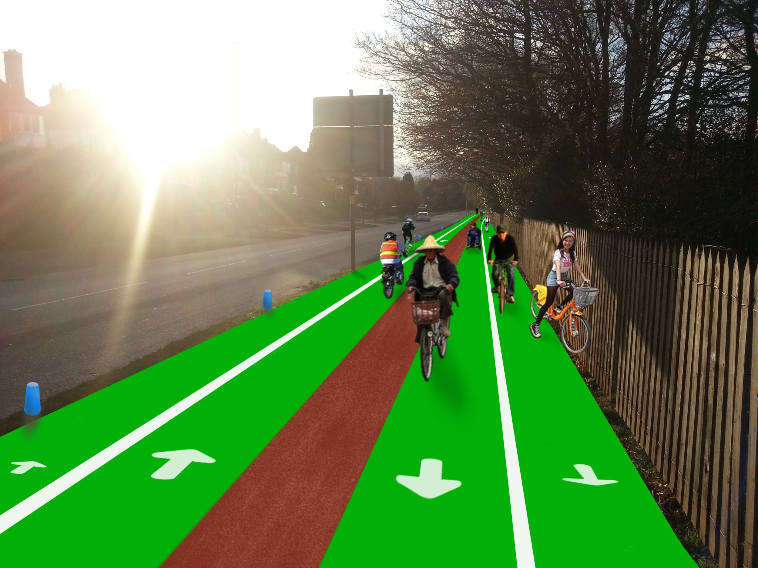
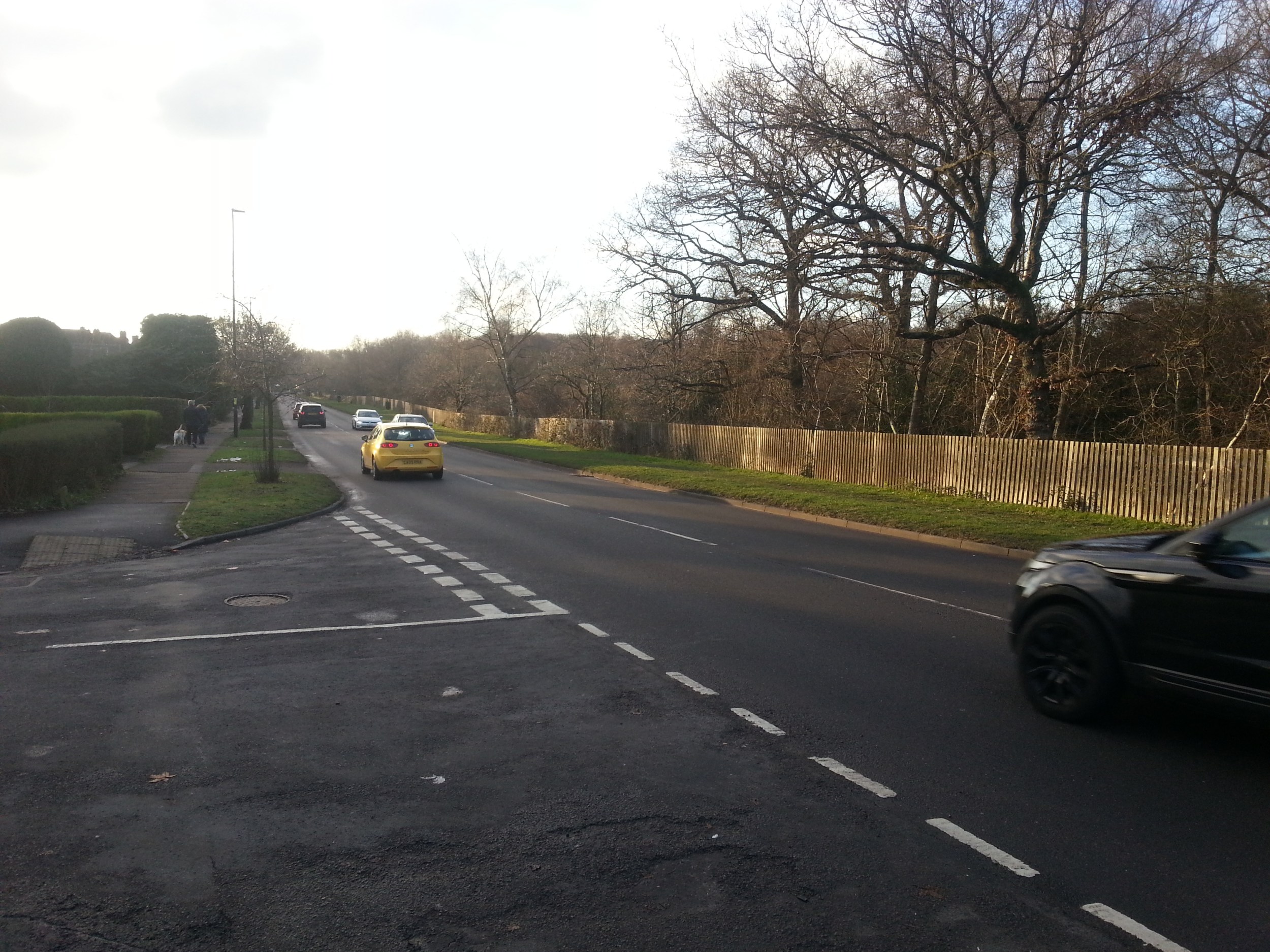
The wide grassy verge on the park side of Monmouth drive is almost entirely unused and is an ideal location for a ‘cycle superhighway’ or ‘cycle scooterhighway’ (henceforth CSH). The potential usefulness is shown by the sheer amount of traffic along this road. The traffic is unsurprising given that this road points from Sutton Coldfield to the geographical centre of the West midlands conurbation connecting Sutton with the highly populated areas of Kingstanding, Old Oscott, Queslett, Pheasey, Great Barr and beyond to Walsall and West Brom.
Many would agree that the amount of traffic and the speed of the vehicles makes cycling or scooting along this road a very unpleasant experience and it’s known for being very unsafe. At least some of the drivers would cycle if this CSH were created therefore reducing pollution and noise for residents. Also the CSH would vastly improve safety and peace of mind for cyclists.
”Why bother? People can cycle in the park.”
- On average it would be much quicker than going through the park. Taking a bike through the park to get to Sutton is a detour for anyone going from some areas around Kingstanding and West of Wylde Green. In the park cyclists often need to stop or slow down for those on foot. Also the park terrain is not flat.
- It would reduce congestion in the park enhancing safety for both the walkers and cyclists.
- It would also provide a safe night-time cycling alternative to going through the park.

Map above showing the proposed route in blue
(All map images from Map data ©2020 Google Earth – used in accordance with Google’s attribution guidelines)

This simple proposal would also create almost zero interference to drivers. Between Banners gate and Somerville Rd there are only two places where cars would have to pull out – the entrance to the Sailing club and golf club and then Stonehouse Rd. Drivers would in fact likely be happier given that many cyclists would be off the road altogether.
Going off a main road onto a well-designed separated cycleway greatly enhances the riders’ peace of mind. – this is something more of us need to experience to realise the true value of such bike schemes.
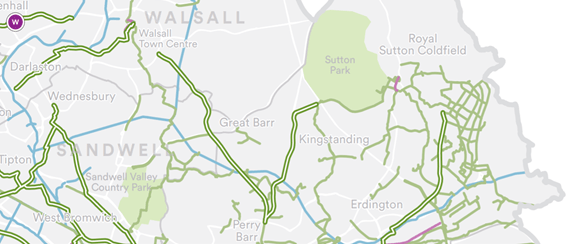
Future extensions – part of a network
Monmouth drive is already a highlighted road within the Starley network plan (below) and connects with the TfWM (Transport for West Midlands) route going down to Perry Barr from where the cycle superhighway leads to the city centre.
An alternative plan shown below – Both the full route above or below could be done almost entirely without using up any car lanes.

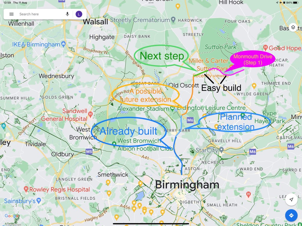
Shown below is a picture of the various possible future extensions.

Rough Rd (light blue-left) is more than wide enough to accommodate a full CSH and this would be the next logical step pending success and popularity of the initial Monmouth drive scheme.
On the Sutton side (right) later options include a small section of Somerville Road and then Wilkinson close (green – right) to be restricted to residents’ cars and cyclists only to form a safer route to Wylde Green train station. The busiest section of Somerville Road beside the park would still be accessible to all cars.
Alternatively Digby Rd (pink – right) could be made one way only for vehicles and incorporate an extension of the CSH. This could possibly in future connect with a CSH going along Birmingham Rd to Wylde Green and Chester Rd (an idea mentioned by others).
More ambitiously, many years in the future an elevated CSH could even run alongside the railway line leading to Sutton train station and possibly Wylde Green train station (light blue vertical line – right).
Or a conventional CSH could be built going through the park towards Sutton station.
Designing for the future – Accommodating transport gadgets
Unprecedented innovation in the field of lightweight transport devices with ever more transport tools, ever more features and constantly increasing range and speed means lightweight portable transport tools – such as escooters – will play a role in our future so we need to allow for this. The efficiency of electric scooters is such that on average a full recharge costs between 10 and 15 pence – this is usually less than one pence per kilometre! Research into their safety has produced mixed results, but a recent review found that escooters are far safer than both bicycles and motorbikes – with rented scooters being even safer still.
The addition of rentable electric scooters and bikes – even along Monmouth drive itself – add value and urgency to this proposal. Wheelchairs and mobility scooters must also be allowed on the CSH.
So to design for the future any CSH must be wide enough to have at least two people side-by-side going in either direction. Two lanes – fast and slow, in both directions making a total of four lanes with a total width of at least 4.5 to 5 metres would be ideal.
Separation between the two directions of travel is important to enhance safety (and distancing). One method would be to use an uneven or gritty surface for the central reservation (as shown in the picture). It should be somewhat unpleasant to ride over at speed but still usable in emergencies.
Responses from the public so far (as of August 2022)
The proposal was put on Nextdoor.com for local residents to voice their views.
As of 15 August the proposal received 21 likes and zero dislikes. But the feedback was more mixed and various concerns were raised:
Some of the perceived problems and concerns:
”Where is the money coming from ?? and who’s going to up keep it after ??”
With previous CSHs, including those in Birmingham, a common complaint is that they are not used and so are a ‘‘waste of space and money.’’ But almost always if a CSH is well designed and well placed usage starts to go up and the benefits become obvious.
If we assume a cost of around £740, 000 per km or less with a length almost exactly 1.6 km (1 mile) then the total estimated maximum cost would be around £1,184, 000. This may sound like a lot and draw complaint. Therefore the clear evidence that well designed bikeways can save lives and money needs to be clearly presented and shared widely while showing that road costs are far far higher than those of bike lanes.
”The trees above will make it greasy and slippy in the wet, the wet leaves in autumn will also be a slide hazard.”
Thankfully no trees will need to be removed, but leaves will need to be cleared away in the Autumn. For this a mini-cleaning truck can be used as happens on the Bristol Rd (A38) bike lane in South Birmingham. The tarmac will need adequate traction.
Other issues raised:
”Is there a surface that allows water to run through and could the design incorporate grass/wild flowers.”
One person mentioned ”the importance of perennial grass verge habitat in regards insect larval development, carbon sequestration, and reducing urban flooding”
”I think its a great idea but it will get used as a car park.”
”no digging under a canopy of a tree as you may do root damage.”
Having looked at the various concerns and having replied to the comments I personally was unable to find any problems that were unresolvable. See the whole conversation HERE (you may have to sign in to Nextdoor.com)
Other issues
There is a bus stop along Monmouth drive so the CSH would need to incorporate space for people to stand waiting. Update in August 2022 – the bus stop is no longer in use anyway!
Some thoughts
There are times when we need to be conservative, hunker down and resist new ideas. There are also times when we need to be liberal and progressive and embrace change. Wisdom is knowing what to do and what not to do. Now, in the middle of a pollution crisis caused by increasing traffic, with global warming, a cost of living crisis with fuel supply issues, while still in a pandemic this is absolutely the time to be progressive and think outside of our metal boxes known as cars. Obviously cars are going to be around given their convenience, but ‘car fundamentalism’ must not stop the adoption of other safer, cleaner, more healthy and more efficient solutions.
If you think this idea is worthwhile please do share this proposal and also go to: https://covidmeasuresbirmingham.commonplace.is/overview
then click ‘Suggest a change to improve walking or cycling’ and navigate to Monmouth drive in Sutton using the map tool and click ‘agree’ with this proposal or any others you would like to see happen.
Thank you for reading!
To download a PDF of the above version of the proposal click HERE
To download the longer & original version of the proposal click HERE

Good posting—rich in detail. See comment below (yellow highlight).
LikeLike
Very good but what about the parking section just before the traffic lights at Clarence Toad
LikeLike
H Ron, Thanks for your comment! Not quite sure where you mean. There are two Clarence Roads in North Birmingham that I’m aware of but neither is close by the proposed bikeway. There is some parking by Somerville Rd though. I guess initially the bike lane could start just where the car parking spaces start – so those parking spaces could be retained initially
LikeLike